
El Niño confirmed
Federal forecasters say pattern this year could be particularly strong

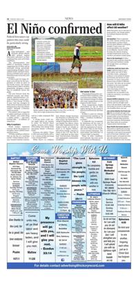
A farmer carries rice seedlings in a paddy field June 3 in Cirebon, West Java, Indonesia. Government officials urged farmers to immediately replant their plots in response to a possible prolonged dry spell linked to el niño.
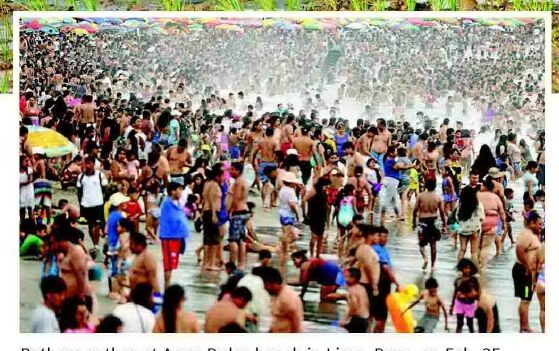
Bathers gather at agua dulce beach in Lima, Peru, on Feb. 25, 2024, due to high temperatures linked to el niño.
Along-anticipated and dramatic global climate shift arrived, federal forecasters said June 11 as they confirmed the start of El Niño conditions.
The announcement also added to mounting evidence suggesting this El Niño will be unusually strong, potentially supercharging droughts, heavy rainfall events and heat waves. Previous El Niños led to some of the hottest years on record, such as in 2024.
El Niño is part of a larger climate cycle driven by the temperature of water in parts of the Pacific Ocean. The natural climate pattern affects weather planetwide, bringing a mixed bag of conditions across the globe.
The new forecast from the National Oceanic and Atmospheric Administration's Climate Prediction Center anticipates a "very strong" El Niño. It may rival the strongest El Niño events in historical record dating back to 1950, the climate center's Michelle L'Heureux said in an email.
The pattern also is expected to reduce hurricane activity in the Atlantic and could bring a milder winter — and lower heating bills — to millions of Americans.
Why it matters
World leaders expressed concern about the prospect of droughts, heavy rainfall events and heat waves.
"El Niño conditions will pour fuel on the fire of a warming world," United Nations Secretary-General António Guterres said in a video statement this month.
A strong event could create ripple effects for months to come. "In NOAA's latest update, we have a 63% chance of becoming 'very strong' in the upcoming winter," L'Heureux noted.
However, she added, "There is still some uncertainty, with a 1-in-3 chance of this not being a very strong El Niño."
While there's no evidence that climate change increases the frequency or intensity of El Niño events, the World Meteorological Organization noted it can amplify the effects. Given that water temperatures in the tropical Pacific are already as much as 10 degrees Fahrenheit above average, concern is rising at the U.N. that this El Niño could feed on that extra heat "and devastate vulnerable and unprepared communities worldwide."
Hot water is key
When federal forecasters confirmed El Niño conditions, they used data from satellites showing sustained changes in winds and water temperatures in the tropical Pacific Ocean.
Those temperatures briefly skyrocketed in the El Niño region during the first week of June to record levels for this time of year.
El Niño is a part of a climate cycle known by scientists as "El Niño — Southern Oscillation," or ENSO.
It originally was recognized by fishermen off the coast of South America in the 1600s, with the appearance of unusually warm water in the Pacific Ocean around Christmas. The name means "the Little Boy" or "Christ Child" in Spanish.
When El Niño conditions aren't present, the cycle can be in neutral or La Niña phases.
How will El Niño affect US weather?
While forecasters say it's too soon to know specifics, the climate pattern has hallmark features that they expect.
Hot weather: There is potential for a drier, warmer summer across the northwest, northern Plains and the upper Midwest, prolonging drought in some areas and increasing wildfire risk, according to AccuWeather. Overall, El Niño increases the chances of Aboveaverage temperatures across the northern and western united states.
Rain in the Southeast: El Niños can lead to wet conditions along the Gulf Coast and southeast, easing the drought there, according to AccuWeather.
California could see more rain, snow: California tends to see a much wetter year with El Niño, said Abby Frazier, a geography professor in the school of Climate, environment and society at Clark university. It's never a guarantee because every El Niño is different, she noted, "But often we can expect conditions to be more favorable for things like atmospheric rivers that bring a lot of rain to southern California." heavier snowfalls also are possible in the California mountains, according to AccuWeather.
Hawaii wildfire concerns: Hawaii may see increased rainfall in the summer, then dry drought conditions in fall and winter, Frazier said. Particularly of concern is the greater risk of wildfire there, she said.
Less active Atlantic hurricane season: We can already see signs of El Niño causing increases in upper-level westerly winds across the tropical Atlantic, Colorado state university hurricane researcher Phil Klotzbach said. These winds act to prevent tropical storms from forming.
Busy Pacific hurricane season: El Niño tends to significantly increase activity in the eastern north Pacific, especially in the central and western parts of the basin, Klotzbach said. Warmer waters, increased low-level spin and reduced vertical wind shear all contribute to this increase.