
Powerful forecast
Meteorologists say a strong El Niño is set to reshape global patterns this year

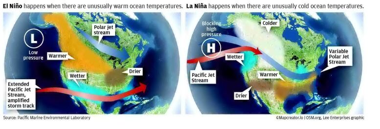

Weeks after the Pacific Ocean engine that helps drive the world's weather shifted into neutral, meteorologists and scientists are now laser-focused on the developing signals of its warm phase — El Niño.
It's what the global forecast models are making of the early signals that is drawing attention.
Virtually all of the models show an El Niño forming in the weeks ahead, and the median estimate across them is for "quite a strong event," said Zeke Hausfather, director of climate and energy at the Breakthrough Institute and a research scientist with Berkeley Earth. "This would put us on track to have an event that is among the strongest El Niños seen in recent history, though it is too early to know with much certainty."
The prospect of a strong El Niño raises fears of additional heat, including marine heat waves and piling on top of long-term climate warming, given its expected arrival at a time when temperatures already have been warmer-than-normal in much of the West and over parts of the Pacific for months. The forecasts raise alarms globally because of the pattern's powerful influence over the world's weather, and a strong event could create rippling effects that last for months.
Previous El Niños fueled wildfires, caused extreme flooding and mega droughts, prompted widespread coral bleaching and disrupted marine life migrations and foraging.
The National Oceanic and Atmospheric Administration once said that to the rest of the global atmosphere, "the arrival of El Niño in the Pacific is like a giant ringing a bell so loudly that it knocks the dishes off the shelves in a house down the street."
What's happening right now?
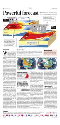
The cooler phase — La Niña — faded into the sunset in early April, and though its effects in terms of drought in parts of the U.S. may linger, El Niño is widely forecast to begin in the weeks ahead. Satellite data shows sea surface temperatures rose sharply in April in the central and eastern Pacific.
But it takes more than just warmer-than-normal waters to meet the threshold NOAA uses to declare an El Niño. It takes water nearly a full degree warmer than average in the El Niño region over a period of time, with a corresponding weakening of the trade winds and response in the atmosphere.
The West and Southwest regions of the country saw their warmest winters on record. The northeast Pacific reached its highest ever average temperature, about 69 degrees, on September 9, 2025, and marine heat waves continued through the winter and into the spring, according to NOAA. In March, ocean waters along parts of the West coast were about 3 to 4 degrees above normal, based on NOAA's latest sea surface temperature measurements.
On March 8, NOAA said the previous 12 months in the lower 48 were again warmer than any other 12-month period, and severe to exceptional drought is occurring over 40% of the continental U.S.
How strong could El Niño be?
While the forecasters and the global models see factors such as an extending plume of warm water in the Pacific that suggest odds are increasing for a strong El Niño, the potential strength of the event remains to be seen.
The eventual outcome is dependent on the wind patterns along the equator in the Pacific over the summer, NOAA said in April.
Several factors are in play. First, the computer models have better accuracy between June and December than earlier in the year, according to the Columbia Climate School at Columbia University. So as the summer progresses, the forecasts are likely to have better precision. Other surrounding weather patterns moving through the atmosphere also can affect El Niño formation and strength. And this year NOAA started using an adjusted index that accounts for the warmer temperatures from climate change before calculating strength, Hausfather said. The method has been debated, but he said it's arguably a better way to remove the effects of "human-driven global warming" so that it doesn't make it appear that El Niños are getting stronger over time.
Does every El Niño act the same?
Three previous El Niños are considered the most intense: 1982-1983, 19861987 and 2015-2016. They were blamed for weather disasters around the world, including floods, extreme droughts and famines in Africa, increased cases of mosquito-borne viruses on the East Coast and a large "blob" of ocean water in the Pacific that killed about a million seabirds.
Do previous El Niños demonstrate what we'll see later this year? Not necessarily. Years ago, NOAA scientist Deke Arndt humorously explained this in a 2015 blog post for the agency's former website Climate.gov.
In your favorite establishment, the staff might bring you your signature beverage when you walk in. But one night you could walk in and the bartender hands you something completely unexpected, wrote Arndt, now director of the agency's National Centers for Environmental Information.
"El Niño is like that bartender," he wrote. Seeing the bartender might tilt your odds toward getting your favorite beverage, but it's not a guarantee. "In other words, sometimes El Niño is the bartender who doesn't bring you what you ordered."
Hurricanes and El Niño
One notable effect of El Niño is a tendency to decrease tropical activity in the Atlantic Ocean. A shift in the path of the jet stream over the United States can spawn downdrafts and sinking winds that have been known to suppress — but not eliminate — hurricane activity in the main region of the Atlantic where hurricanes often form. Those winds can prevent storms from building the self-sustaining structure they need to become hurricanes.
However, the National Hurricane Center and others warn that storms, even major devastating hurricanes, can and do occur in El Niño years, particularly in the Gulf of Mexico. When comparing 15 of the warmer El Niños on record, at least 37 named storms made landfall in the contiguous United States, including 14 hurricanes.
La Niña and wildfires
Even as conditions shift, researchers warn lingering effects from La Niña can still contribute to increased wildfire activity.
A recent study by the Cooperative Institute and NOAA researchers found a strong link between fall La Niñas and an increase in spring fire activity. It reported a two-fold increase in the relative risk of extensive burns in the South, Southwest and Rocky Mountains, as well as risks in the Great Basin and Northern California regions in summer. An autumn El Niño appears to elevate the risk of large fires in the eastern and northern Rocky Mountains in the spring.
The El Niño oscillation "offers a powerful tool for predicting the likelihood of extensive wildfire activity in several U.S. regions up to a year out," said Andrew Hoell, a NOAA researcher and lead author of the study published in the Journal of Geophysical Research: Atmospheres.
As the vast Pacific engine begins to shift again, scientists will watch to determine how the world's weather will change in the months ahead.
What is El Niño?
The natural, recurring pattern in the central and eastern Pacific Ocean cycles between three phases: el Niño, La Niña and neutral. First documented by fishermen off the west coast of south America in the 1600s because it brought unusually warm water to the eastern Pacific, its effects extend far beyond that coast.
Disturbances over the Pacific Ocean have such a far-reaching potential for impact because the ocean is so large. It influences where ocean heat is released into the atmosphere, affects atmospheric circulation, temperatures and precipitation around the world.
Name connection
Fishermen in Peru in the 19th century noted that unusually warm waters would reduce the number of fish near Christmastime. so they dubbed the phenomenon "el Niño," in reference to the Christ child.
Conditions favorable
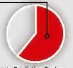
61% chance el Niño is likely to emerge this May or June and persist through at least the end of the year. National Weather service Climate Prediction Center
To the rest of the global atmosphere "the arrival of El Niño in the Pacific is like a giant ringing a bell so loudly that it knocks the dishes off the shelves in a house down the street."
— The National Oceanic and Atmospheric Administration